

The Draft Master Plan 2013 (DMP2013) guides Singapore’s development over the next 10 to 15 years. All Singapore's wild places are treated under Recreation. In a section on In touch with nature, under the heading "Enhancing Nature Areas for Biodiversity and Education", the DMP2013 highlighted Pulau Ubin:
Pulau Ubin, much beloved by Singaporeans, will remain as a rustic retreat. There are plans to enhance its value as a nature area by restoring habitats on land that had previously been cleared as a result of activities like agriculture and quarrying. With new initiatives such as the Northern Boardwalk, it is more comfortable for visitors to get around on the island. Pulau Ubin will become a more inviting classroom for kids and even adults to learn about nature and environmental sustainability.
and included this cartoon diagram.

 |
| click on image for a larger view. |
Our Rustic Playground – Pulau UbinAlso announced under "Bringing Nature Closer to Homes" is Coney Island Park
Pulau Ubin is today a much-treasured nature haven in Singapore, with mangroves and waterbodies set amidst lush forests. The island will continue to be kept as a rustic playground for Singaporeans, with carefully planned improvement works to create more opportunities for recreation and nature enjoyment.
This will allow for greater appreciation of the island’s natural attractions, while at the same time enhancing biodiversity and preserving the unique characteristics that make Ubin a key area of natural beauty. The area currently used by Outward Bound Singapore will be opened up for organised visits for outdoor enthusiasts and nature lovers.
A new rustic park on Coney Island in Punggol will be completed by 2015, providing an enchanting back-to-nature haven away from the bustle of mainland Singapore. The park will be well integrated with the wider park connector network within the North-East, with easy access to the upcoming Round Island Route as well as the North Eastern Riverine Loop.
Under details for "Recreation in the East Region" there is mention of "New park connectors will also allow residents to walk or cycle between areas like Punggol and Pasir Ris Park, as well as beyond. Existing parks will also be refreshed, like Changi Beach Park, which now enjoys new pavilions, paths, shelters and playgrounds."
In the brochure for Pasir Ris, there is mention of "Enhancements at Sungei Api Api and Sungei Tampines under Active, Beautiful and Clean (ABC) Waters projects by PUB, including the landscaping of river banks, new lookout decks, shelters and seating ; and a kayak launch pontoon on the east bank of Sungei Api Api.

In the brochure for Changi, it is mentioned that there will be a realigned Changi Coast Road to serve Changi and widening of Tanah Merah Coast Road


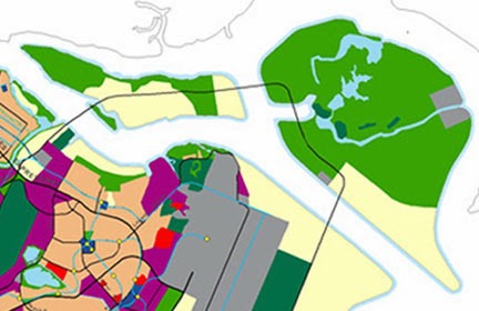
Looking at the land use plan for Pulau Ubin in the map of the Draft Master Plan 2013.
 |
| Draft Master Plan 2013 |
 |
| Master Plan 2008 |

This is the map using the Parks and Waterbodies 2013 overlay.

 And let's compare the Draft Master Plan 2013:
 |
| Olive green=Open space, bright yellow=Reserve site |
 |
| Light green=Open space/recreation/agriculture Pale yellow=Reserve site. |
These are the existing natural shores that may be impacted by the 'Reserve sites' of both the Draft Master Plan 2013 and the Land Use Plan following the Population White Paper.
 |
| click on image for larger view |
What can one person do about this?
Speak up for what you love!
- URA is seeking YOUR feedback on the Draft Master Plan by 19 Dec. I gave feedback to URA in 2008 and they replied and they even agreed to visit Cyrene Reef with me. So your feedback CAN make a difference!
- Join the Conversation: "Our Singapore Conversation on Green Spaces" 30 Nov (Sat):
What are specifically the “green spaces” that the majority of people prefer? More of the usual manicured public parks? More nature parks with an emphasis on conserving wild greenery and its wildlife? More managed green areas for recreation like golf-courses, football? It is important that the term “green space” be clearly specified by the people so that national planning can proceed on the right track and be relevant to the people. In this session, we aim to gather people from a wide variety of sectors (professionals, heartlanders, students, sportsmen, etc.) to thrash out these issues.
Organised by the Nature Society (Singapore) and Young NTUC.
Don't take our shores for granted!Date: 30 Nov (Sat)Time: 2.30 – 5.30pm
Venue: NTUC Centre, No.1 Marina Boulevard, Level 8 Room 801, One Marina Boulevard
Moderator: Ms Faizah Jamal (Nominated MP)
More details on the Green Drinks blog
You can make a difference! Simply explore, express and ACT!
Visit our shores before they are gone. Join nature activities at our wild places, like those listed on wildsingapore happenings. Share what you've seen. Volunteer for them.
Related posts
- What shores will Singapore lose in 7-million population plan?
- Reply to URA on the Draft Master Plan 2008
- URA replies to my feedback on the Draft Master Plan!
Here's more info, photos and stories about our trips to these shores.
- Pulau Ubin on wildsingapore, posts on this blog, photos on wildsingapore flickr
- Beting Bronok posts on this blog, photos on wildsingapore flickr
- Chek Jawa on wildsingapore, posts on this blog, photos on wildsingapore flickr
- Pulau Sekudu posts on this blog, photos on wildsingapore flickr
- Changi Beach posts on this blog, photos on wildsingapore flickr
- Pasir Ris shores and mangroves on wildsingapore, posts on this blog, photos on wildsingapore flickr
- Punggol beach posts on this blog, photos on wildsingapore flickr
- Tanah Merah posts on this blog, photos on wildsingapore flickr
